According to the The Press of Atlantic City NJDOT will be conducting a feasability to study to extend the Ocean City Rail Trail from 36th to 49th Streets. The rail trail will be extension of Bike Route OC1 connecting the Haven Avenue Bicycle Boulevard which begins at 9th Street to the multi-use trail at Corson's Inlet (at the south end of the island).
The trail is proving to be controversial because it uses an old rail bed built on top of a wetland. There is a second proposal if the project is killed that may be equally controversial. That one moves the bike lanes on adjacent West Avenue on to the west side and create a two way cycletrack.
More info on these proposals can be found on the Bike Ocean City website.
Monday, December 6, 2010

Sunday, December 5, 2010
DRPA plans bike/ped ramp on The Ben Franklin Bridge to better connect Philly & Camden
The following was originally written by John Boyle and posted on the Greater Philadelphia Bicycle News. It is reprinted here with the permission of our friends at the Bicycle Coalition of Greater Philadelphia.
The Bicycle Coalition met with officials of the Delaware River Port Authority (DRPA) last week to receive details of the plan for the Bicycle Pedestrian Ramp project on the South Walkway of the Bridge as well as the Pearl St project which will offer bicycle and pedestrian improvements from the walkway entrance to the river. Pearl Street is one of three Camden TIGER projects sponsored by the Coopers Ferry Development Association.
The Bicycle Coalition met with officials of the Delaware River Port Authority (DRPA) last week to receive details of the plan for the Bicycle Pedestrian Ramp project on the South Walkway of the Bridge as well as the Pearl St project which will offer bicycle and pedestrian improvements from the walkway entrance to the river. Pearl Street is one of three Camden TIGER projects sponsored by the Coopers Ferry Development Association.
Pearl Street Project
DRPA put up $100,000 to design the streetscape and roadway. The project calls for new signage, belgian block sidewalk and lighting improvements and sharrows on the roadway. Final design is within days of completion and construction is scheduled to begin in April 2011 and is expected to be completed within 6 months. The other Camden projects Pine St and MLK Blvd are expected to be completed simultanously and these 3 projects should be among the first TIGER projects to go under construction.
Bicycle and Pedestrian Ramp
As we reported earlier pending board approval DRPA is budgeting $50,000 in 2011 for the design of the ramp, while there was an original 2011 committment of $100,000 for the 2011 capital budget DRPA Chief Acting Engineer Michael Venuto explained that the 2011 schedule only required half that amount for the fiscal year. The rest of the design work, which is expected to take about 7 months will be completed in 2012. Construction is expected to begin around November of December of 2012 with completion scheduled in the Spring of 2013. The South Walkway will have to be closed during the six month construction project. Total project cost is estimated at 3.3 million dollars.
The bottom line-Nothing but good news from the DRPA, the construction of the ramp now appears to be a certainty. The Port Authority should also be commended for stepping up and offering their expertise to develop the plans for the first bicycle facilities in Camden.

Friday, December 3, 2010
The New Brunswick Bikeway – Much more than bike lanes
Last week at the November Middlesex County Transportation Coordinating Committee Meeting it was announced that the New Brunswick Bikeway was in final engineering design and that the project was or would soon be put out to bid. The project would build 1.9 miles of bike lanes from the intersection of Lafayette St and College Ave near the Route 18 John Lynch Bridge at its western terminus, to George Street and Bishop Street at the edge of the Douglas Campus to the east. From Lafayette Street, the bikeway would run on College Ave to Huntington St, then down George St to Albany St (NJ Rt 27). At Albany there would be a spur that will run south to the train station while the main route would head north to Neilson St. Then the bikeway would head east along the entire length of Neilson St to Bishop St were it will turn right for a few hundred feet back to George St.
 Overview diagram of the eastern portion of the New Brunswick Bikeway.
Access to diagrams and report courtesy of the Middlesex County Planning Department.
As part of the construction of the bikeway, every street the project impacts will be repaved, intersections will be updated to comply with ADA standards, traffic signals will be redesign and retimed with new hardware if necessary, the median along Albany street will be narrowed and realigned in places, and bicycle racks will be installed in select locations. As this project does much more than simply paint lines on the roadway, $7.1 million has been allocated to fund the construction of the project.
 Overview diagram of the western portion of the New Brunswick Bikeway.
Access to diagrams and report courtesy of the Middlesex County Planning Department.
While this blog has been critical of this project in the past, having looked at the final layout and gaining a better understand what the project entails, makes us feel more comfortable with what the project will give New Brunswick cyclists. While the project regrettably still reroutes cyclists away from the core of New Brunswick’s downtown, it does contain much that will benefit cyclists. The bike lanes along Albany St from Neilson to the train station will aid those living Highland Park reach the station. The bike lane along the length of George St west of Albany is a perfect route for cyclists between parts of the College Ave Campus and downtown. And while Neilson St might not be the most ideal route for cyclists traveling between the College Ave and Cook/Douglas Campuses, the bike lanes along this street will make it easier for cyclists coming from Highland Park to get to the Cook/Douglas Campus as well as some destinations downtown.
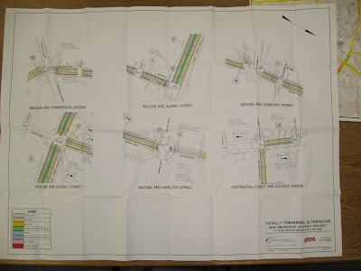 Detail diagram of the major intersections along the New Brunswick Bikeway.
Access to diagrams and report courtesy of the Middlesex County Planning Department.
What is also really interesting is that the New Brunswick Bikeway will also have the first modern, on-street, contra-flow bike lanes in New Jersey, at least that WalkBikeJersey is aware of. These lanes would be located on Neilson and Bishop Streets and look fairly well though out. The one area where the contra-flow lane leaves us with some concern is in a small area on Neilson St where cars facing the opposite direction of the contra-flow bike traffic would park between the contra-flow lane and the curb. Despite this minor concern, these contra-flow bike lanes will serve as an example in New Jersey of this type of unique bicycle facility. If they work well here (as I believe they will as contra-flow bike lanes are common in Europe and in some locations in the US) then other places in New Jersey will be more likely to build them in their own towns to better and more conveniently serve cyclists where needed.
 Overview diagram of the eastern portion of the New Brunswick Bikeway.
Access to diagrams and report courtesy of the Middlesex County Planning Department.
As part of the construction of the bikeway, every street the project impacts will be repaved, intersections will be updated to comply with ADA standards, traffic signals will be redesign and retimed with new hardware if necessary, the median along Albany street will be narrowed and realigned in places, and bicycle racks will be installed in select locations. As this project does much more than simply paint lines on the roadway, $7.1 million has been allocated to fund the construction of the project.
 Overview diagram of the western portion of the New Brunswick Bikeway.
Access to diagrams and report courtesy of the Middlesex County Planning Department.
While this blog has been critical of this project in the past, having looked at the final layout and gaining a better understand what the project entails, makes us feel more comfortable with what the project will give New Brunswick cyclists. While the project regrettably still reroutes cyclists away from the core of New Brunswick’s downtown, it does contain much that will benefit cyclists. The bike lanes along Albany St from Neilson to the train station will aid those living Highland Park reach the station. The bike lane along the length of George St west of Albany is a perfect route for cyclists between parts of the College Ave Campus and downtown. And while Neilson St might not be the most ideal route for cyclists traveling between the College Ave and Cook/Douglas Campuses, the bike lanes along this street will make it easier for cyclists coming from Highland Park to get to the Cook/Douglas Campus as well as some destinations downtown.
 Detail diagram of the major intersections along the New Brunswick Bikeway.
Access to diagrams and report courtesy of the Middlesex County Planning Department.
What is also really interesting is that the New Brunswick Bikeway will also have the first modern, on-street, contra-flow bike lanes in New Jersey, at least that WalkBikeJersey is aware of. These lanes would be located on Neilson and Bishop Streets and look fairly well though out. The one area where the contra-flow lane leaves us with some concern is in a small area on Neilson St where cars facing the opposite direction of the contra-flow bike traffic would park between the contra-flow lane and the curb. Despite this minor concern, these contra-flow bike lanes will serve as an example in New Jersey of this type of unique bicycle facility. If they work well here (as I believe they will as contra-flow bike lanes are common in Europe and in some locations in the US) then other places in New Jersey will be more likely to build them in their own towns to better and more conveniently serve cyclists where needed.
Thursday, December 2, 2010
Marty announces New Jersey's first Gran Fondo in Morristion
Those of us in attendance at yesterday's NJ Bicycle Map workshop, we were given a bit of a scoop from Marty Epstein of Marty's Reliable Cycle as he let us know that he would be announcing New Jersey's first Gran Fondo cycling event today. Scheduled for Sunday, August 28th in 2011, the Gran Fondo will be the feature event of a three day bicycle extravaganza that Marty expects to attract 1000 to 3000 participants to Morristown.
For more, read the article in today's Morristown Green. More details to come as we get them at WalkBikeJersey.
For more, read the article in today's Morristown Green. More details to come as we get them at WalkBikeJersey.
Turnout high at first state bicycle map workshop
Close to 30 people attended the first workshop meeting for the New Jersey Bicycle Map, held yesterday at the Frelinghuysen Arboretum in Morris County. Those in the audience included representatives from several county governments, members of local cycling clubs, a prominent local bikeshop owner (Hi Marty!) and other concerned citizen cyclists. Representatives from NJDOT, The RBA Group and Steve Spindler of Steve Spindler Cartography were also there to discuss the impetus for the map project and what they hope to accomplish in the finished project.
To start the conversation Steve Spindler gave a presentation into how the map is being put together, from what sources the data is being acquired and the financial and physical limitations on the project. Mr. Spindler even honored WalkBikeJersey by featuring our article “What should a statewide bicycle map have?” in his presentation. Better yet he even liked all of the suggestions made in that article (I’m glad someone is paying attention to this blog).
Of all the questions asked by the participants probably the best and most profound was “what should the map tell people and who is the target audience?” This is probably the crux issue that will guide the final design of the map. Understanding that the map brought to the meeting is still a very rough draft, many audience members were still very concerned that the final map might not be at all useful for those wishing to navigate New Jersey's roadways by bicycle. Others noted that the map only gives people the idea that cycling is possible in New Jersey but that to actually navigate by bicycle the map should point people to other resources like county bike maps, local clubs or even other online sources like NJBikeMap.com and MapMyRide. Others said that this might not be such a bad idea as the map might act like tourism aid. Still many felt that the map needs to do both; aid in navigation while promoting the possibilities of bicycling in New Jersey.
Talk also did seem to focus on the relatively small scale of the map and that it might be too small to be useful for bicyclists. However, the discussion did hint that the current two-map layout is not a done deal and that other possible larger scale configurations are possible by either using larger sized maps or by dividing the state into more that two sections.
Overall, this workshop was a success. However one did get a feeling that the final product in this first edition might not be what many audience members are looking for, namely an aid to navigation. The potential cause of this seemed to be mostly due to budget, data source, layout, and time limitations in this first project scope. However this does not mean that this first edition map is already destine to disappoint. If the map designers can get a hold of good quality source data from local governments, counties, bicycle clubs and from cyclists themselves, this first edition map could still be a first rate product. Even if it is less than perfect all in attendance were reminded that this is only a first edition and that future editions and online revisions will always allow for improvements at a later date.
If you didn’t attend the first meeting, don’t forget that there will be two more workshop meetings coming next week in Central and South Jersey. From what I overheard, the South Jersey meeting had very few RSVPs at this time and that those working on the project really need to hear from the folks in the south whether they be government officials or local cyclists. If you live in South or Central Jersey please try to attend the next to workshops if you can to help make this the best statewide bicycle map anywhere. Don't forget that all are encouraged to review the draft map on the interactive website, (http://bikemap.com/njbike/) where you are requested to RSVP for the session you plan on attending.
Central Jersey
Tuesday, December 7
9:30am to 11:30am
NJDOT Headquarters
1035 Parkway Ave
Trenton, NJ
South Jersey
Wednesday, December 8
10:00am to 12:00 noon
The George Luciano Family Center
Cumberland County College
Vineland, NJ
Wednesday, December 1, 2010
No Duh! Aussie study finds drivers at fault 87% of conflicts with bicyclists
I got wind of this story from Streetsblog's Daily Headlines:
From a site called Bicycle Radar comes the story "Drivers at fault in majority of cycling accidents".
(Read the story first before continuing here.)
As a cyclist who takes my responsibilities as the operator of a vehicle very seriously, I find the results of this report to be right on the money with the reality I see on the streets here in New Jersey. Even when following the letter of the law to my best abilities, I constantly have issues with motorists. Dangerous passing including passing too close, passing on blind turns and passing on narrow roads with oncoming traffic make up the vast majority of issues I have with motorists. Still, such incidents add up very quickly on a 2 hr, 40 mile ride. It's not uncommon for me to have up to 10 such uncomfortable incidents on a ride of such length on roads with very little traffic. I've even had three incidents in the past 14 months where I followed my LCI training, took the lane and tried to waved off the overtaking vehicle on a blind turn or rise, only to have the vehicle ignore my actions go, for the pass and nearly cause a head-on collision with the on coming car. What else can one do to proactively defend one's self on the road!
For those of you interested in more here's the link the abstract of the original study called "Naturalistic Cycling Study: Identifying risk factors for on-road commuter cyclists."
Morristown Planning Board to discuss bike plan addendum
I caught this from Kendra on Morristown Pedal Pushers:
Tomorrow December 2nd, the Morristown Planning Board will be discussing an addendum to their bicycle plan. This addendum gives some actual proposals for street improvements to aid cyclists and where those improvements should go. A copy of the Morristown Bicycle Plan Addendum can be found here.
My quick, ten minute review of the plan seems to indicate that the consultant has come up with some good ideas to improve cycling around the town. Morristown is full of wide multi-lane roads, many of which seem ridiculously overbuilt for the traffic that they handle and are also engineered for high traffic speeds (Lafeyette and Madison Avenues are perfect emamples). Others are really busy much of the time, like South St and Speedwell Ave and would seem to pose more difficulty to accommodate both cyclists and the high motor-vehicle traffic volume. Oddly enough this addendum seems to find solutions at this time for the narrow roads with higher traffic volumes than the overbuilt ones. This isn't at all bad since the busy roads also happen to be in areas that seem to have more bicycle traffic and/or take local cyclists to places in town that they need or want to go.
I must admit however that I am concerned about the proposed use of "Sharrows" on Speedwell and Sussex Avenues shown on page 43 of the document. The image of the intersection seems to place the Sharrows dab-smack in the door zone of parked cars. If they propose to use "Bicycles May Use Full Lane" signs then the Sharrows should be placed in the center of the lanes or at least out of the doorzone. Still, this might be a detail better clarified in the text and I do again confess to having only spent little more than 10 or 15 minutes reviewing the plan.
What was really interesting was the crash analysis. A high percentage of crashes seemed to have been caused by cyclists riding on the sidewalk and when using the crosswalks. This seems to fully support those who espouse Effective Cycling techniques and who say that riding a bike on the sidewalk is a very dangerous.
Again, if you live in Morristown or in the area, make sure you show your support of the plan but also don't be afraid to bring up your concerns. Just make sure you do so politely and in a way that won't result in a scuttling of the entire proposal since there really seems to be some really, really good stuff in this plan.
Subscribe to:
Posts (Atom)